

Ecohydrology: The Relationship between Earth and Sky
Ecohydrology: The Relationship between Earth and Sky
An observation by Robert Horton more than 90-years ago gave birth to a discipline that is providing some meaningful insights today about our place on this watery planet


Ecohydrology is the study of the interactions between water and ecosystems, but when I went back to school in the late 80s-early 90s it was not much discussed. My course work was in civil engineering and the earth sciences and I was focused on the processes powered by wetland plants and the rhizosphere (the zone of chemical, biological and physical influence generated by root growth and activity). For example, many wetland plants pull oxygen from the air and diffuse it out their roots into the rhizosphere. This converts oxygen-starved areas into oxygenated zones, root by root. The oxygenated and anoxic (little to no oxygen) zones exist side by side outside the root, supporting very different biotic communities each with their own unique but complementary energy and nutrient cycles.
My focus has since moved up slope. I am obsessed with terrestrial root systems and the habitats they help construct. My field work consists of walking the land and wading streams. Precipitation, streamflow and land cover are my primary data. But no matter where I work, no matter how much I study equations and models, I always feel like I am missing something. The pieces do not completely fit together.
A big part of my work is to understand and predict the relationship between rain and streamflow. We measure both and build computer models to try and emulate the patterns in the data we see. We can establish strong correlations for rain and runoff in areas covered with rooftops, roads and parking lots, but when it comes to undeveloped, rural areas, it is much harder to establish the same strong correlations.
In 1933, Robert Horton, one of the pioneers of modern American hydrology, published “The Role of Infiltration in the Hydrologic Cycle”, in the Transactions of the 14th Annual Meeting of the American Geophysical Union. The motivation for the work, Horton said, was to find a reasonable correlation between rainfall and runoff. Predicting runoff and flooding from rainfall is still a fundamental problem in hydrology – how does one do it?
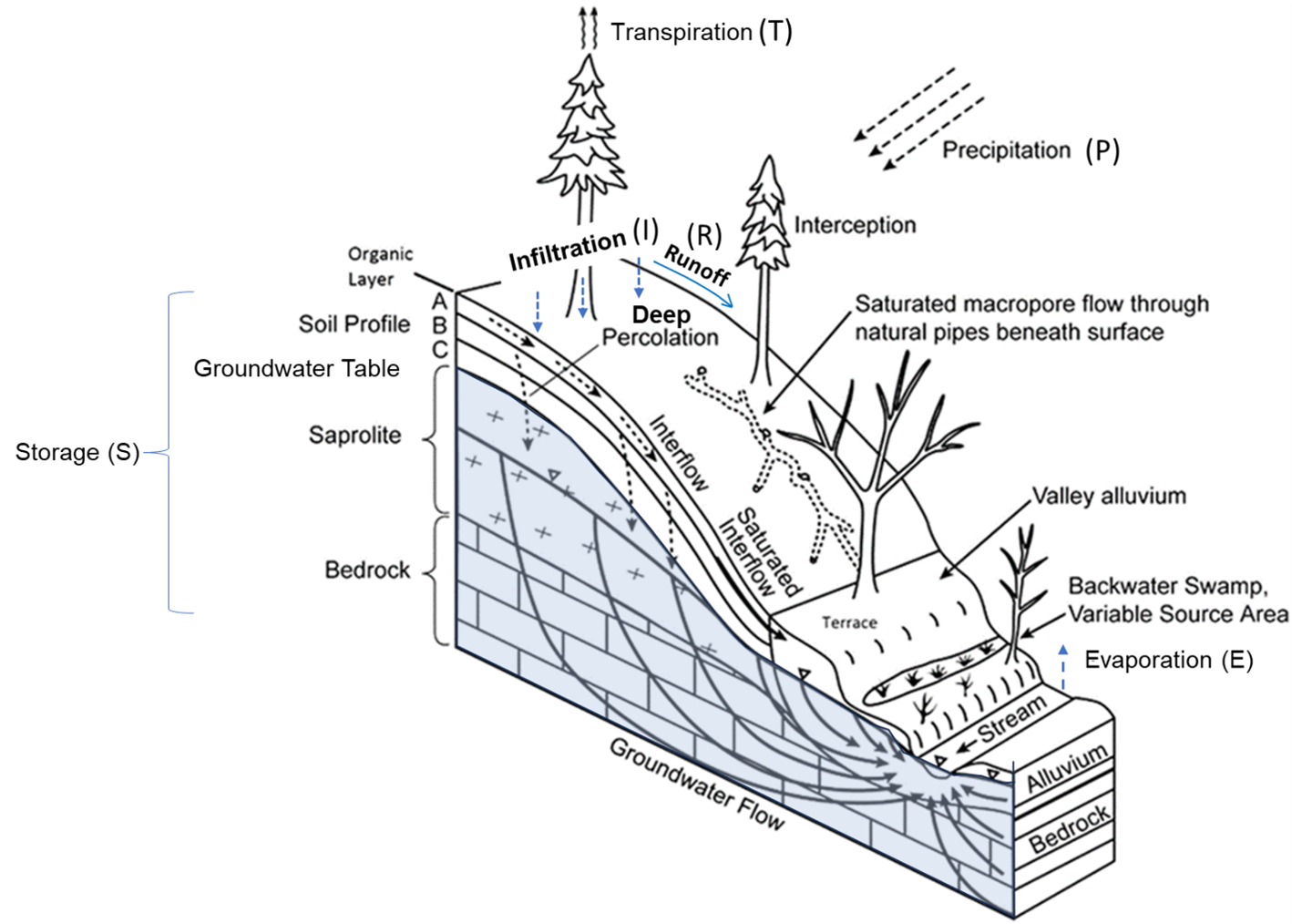
To help better answer this question, Horton recommended that, “various hydrologic problems are simplified by starting at the surface and pursuing the subsequent course of each part of the rainfall”. This description of the ‘subsequent course(s) of the rainfall’ that Horton refers to, is also known as the process of “hydrologic partitioning”. Typically, when estimating runoff we partition precipitation (rain and snow) into these components (also refer to the Flow Path Figure below):
Runoff = Precipitaion – Evapotranspiration – Infiltration – Storage or
R = P – ET – I – S.
Precipitation (P) can consist of both rain and snow, but here I will just focus on rainfall during the growing season. The falling rain can be partitioned into water that runs off the ground (R), seeps into the ground (I), is returned to the air via evaporation (E) and transpiration (T) or is stored (S) in the ground.
In his infiltration paper, Horton hydrologically partitioned fallen rain into its component parts on a largely forested watershed in the Catskill Mountains on the West Branch of the Delaware River. A stream gage in roughly the same location as the one Horton used for his flow data is still at Hancock and Hale Eddy in New York. He used continuous, daily stream flow and rainfall data there from 1905 to 1929 to drive the partitioning analysis.
Water that doesn’t run off the landscape and that doesn’t seep into the ground is ripe for evaporation. Water sitting on leaves, shoots, branches, trunks, detritus or the ground can all be sucked back up into the sky when the air and water gradients are right. Water that is absorbed back into the ground can make its way back to the atmosphere sucked up by roots and pulled back into the sky through the plant as transpiration. Or the water is stored or moved by roots and fungi in and out of spaces built by biotic and abiotic means. Almost any kind of stone or rock can also hold some water. There can be potential liquid water storage throughout the surface of the earth down through saprolite (partially decayed bedrock) and into bedrock (refer back to Flow Path Figure).
Surface runoff from pervious ground, as Horton defined it and as is now understood, can occur when rainfall intensities exceed the ground’s infiltration capacity or when water collects at landscape lows, arriving there as water already infiltrated into the ground from up slope. In this conception of infiltrated water, it has shallowly advanced downward but is still above the groundwater table. It could be interflow (flow between the top of ground and groundwater) that rides above a poorly draining layer; or that traverses pore space networks or potentially moves from root to root, down slope and gets “re-expressed” as surface water. As I heard it called in Costa Rica, this spot where water comes out of the ground: “nacimiento del agua” - the birth of water. It seeps out; it feeds wetlands; it runs down rills, runnels and ephemeral channels. It keeps collecting and accumulating, becoming lakes, perennial streams, rivers, estuaries and oceans.
Horton found that despite significant variability in growing season annual rainfall (min = 16-inches and max = 33-inches), surface runoff remained fairly low and the ratio between ET to the amount of water infiltrated remained nearly constant. Horton said that runoff and streamflow are: “dependent on the complex interrelations between climate, geology, infiltration-capacity, field-moisture capacity [how much water a soil can store in its pores], groundwater [replenishment] and vegetational activity”. This ratio more than 60-years later was christened the Horton’s Index (See Horton Index Figure below).

Perhaps the ‘vegetational activity’ Horton was referring to was just ET. I’m not sure. I just know the vegetational activity I am thinking of is complex and still poorly understood. Plants are extraordinary. They negotiate air, water, and earth with other life forms. They are sentient (but perhaps not reflecting on their meta-selves) and are in relationships with all other living beings and the forces of the earth. They take in information, they process it and they act upon it. They react to relationships and forces in the present but seem to be able negotiate preservation and growth over extraordinarily long time-scales.
Eagleson (1992) hypothesized that plants and their roots develop gradually and synergistically with the climate. Shoots and roots build productive, water efficient soils that store and conduct water in ways that can continuously amplify the growth of plant individuals and plant populations up to an optimum, asymptotic limit. This productivity optimization is driven by water and energy availability and realized via evolutionary pressure. While the energy availability is largely a function of geography, water availability over the terrestrial earth strongly affects and is strongly influenced by plants.
Work since Horton’s paper has extended this kind of hydrologic partitioning to landscapes all around the globe. In 2009, Troche, et.al, first used the term “Horton Index” talking about it as inspiration for their work hydrologically partitioning data from 89 watersheds mostly in the Southeastern US but also in California, Oregon and Washington. They concluded across a range of ecosystem types and spatial scales that vegetation becomes more efficient in its water use as water becomes scarcer.
The longer natural plant communities are left undisturbed, the more climate resilient they tend to become. As Michael Godfrey in his Field Guide to the Piedmont puts it: “The term climax defines that cloak of vegetation which ultimately covers the land in the absence of [human] disturbance over a sustained period. Stability is the salient characteristic of the climax growth…”
Plant communities adjust to an evolutionary pressure that selects for hardiness and adaptation. And because plants are mostly sessile (do not move), they occupy new locations via growth and networking. Through growth, plants change their location but remain whole. As they grow and change, they also change their circumstances by re-structuring the world. The more they grow, the more capable they are of influencing the world. Individual plants are the centers of local transformations of water, sky and ground and their ubiquity, connectedness and stability translate globally.
One of Horton’s conclusions in the paper was: “The meaning of the constancy of this ratio [the Horton Index] has to be that the natural vegetation of a region tends to develop to such an extent that it can utilize the largest proportion of soil moisture supplied by infiltration.” Now when I hear this it seems like a real mouthful to me! In that mouthful, I think, you can pretty well fit the vast expanse of ecohydrology. That expanse is what I aim to explore.
Fantastic read! It brings to mind a recent opinion paper in HESS by Gao et al (https://doi.org/10.5194/hess-27-2607-2023) that questions our reliance on soils in our hydrologic models. It suggests we instead start with the terrestrial ecosystem because it manipulates the soil, rather than the reverse. Thanks again, loving your posts!
There attempts to model rain-runoff with nonlinear dynamics models. There's some evidence that it behaves with chaotic strange attractors. See my essay https://climatewaterproject.substack.com/p/how-does-rain-turn-into-floods-a